Nepal
|
नेपाल
Nepāl(Nepal Bhasa:नेपा:) |
||||
|---|---|---|---|---|
|
||||
|
Motto जननी जन्मभूमिष्च स्वर्गादपि गरीयसी (Sanskrit) "Mother and motherland are dearer than the heavens" |
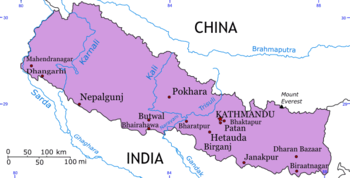
Nepal, officially known, according to its Interim Constitution, as the State of Nepal (previously known as Kingdom of Nepal) (Nepali: नेपाल [neˈpaːl] (help·info)) is a landlocked Himalayan country in South Asia. In Nepal Bhasa, Nepal is called as Nepa: (Nepal Bhasa: नेपा:). It is bordered by China (Tibet) to the north and by India (Bihar, Sikkim, Uttar Pradesh, Uttarakhand) to the south, east and west.
For a small territory, the Nepali landscape is uncommonly diverse, ranging from the humid Terai in the south to the lofty Himalayas in the north. Eight of the world's ten highest mountains are in Nepal, including Mount Everest. The country is famous for: tourism, trekking, hiking, camping, mountain biking, national wildlife parks, jungle safaris, river rafting, sport fishing, and its many beautiful temples and places of worship.
Kathmandu is the capital and largest city. Other main cities include Dharan, Thimi, Pokhara, Biratnagar, Lalitpur (Patan), Bhaktapur. other main towns includes Birendranagar, Bharatpur, Nepal, Siddhartanagar (Bhairahawa), Birganj (Birgunj), Butwal, Janakpur, Nepalganj (Nepalgunj), Hetauda, Damak, Dhangadhi, and Mahendranagar.
After a long and rich history, during which the region splintered and coalesced under a variety of absolute rulers, Nepal became a constitutional monarchy in 1990. However, the monarchy retained many important and ill-defined powers. This arrangement was marked by increasing instability, both in the parliament and, since 1996, in large swathes of the country that have been fought over by Maoist insurgents. The Maoists, alienated from mainstream political parties, went underground and started a guerrilla war against both monarchy and mainstream political parties. They have sought to overthrow feudal institutions, including the monarchy, and establish a Maoist state.
This led to the Nepalese Civil War in which more than 15,000 people have died. After the intra-party conflict within the ruling Nepali Congress (NC) on the issue of continuation of state of emergency to deal with Maoist insurgents, then prime minister Sher Bahadur Deuba recommended the king for the dissolution of lower house seeking a fresh mandate in 2002. The king accepted his recommendation and dissolved the house as per the constitution. Later on, Deuba recommended the king for the postponement of the parliamentary election on the pretext of insecurity due to the Maoist insurgency. Then the king sacked Deuba in 2002 on the grounds of not able to hold elections and started ruling through prime ministers appointed by him. He then unilaterally declared a state of emergency early in 2005 and assumed all executive powers.
Following the 2006 democracy movement, the king agreed to relinquish the sovereign power back to the people and reinstated the dissolved House of Representatives on April 24, 2006. Using its newly acquired sovereign authority, on May 18, 2006, the newly resumed House of Representatives unanimously passed a motion to curtail the power of the king and declared Nepal a secular state. As of September, 2006, a complete rewrite of the constitution was still expected to happen in the near future.
As of July 2007, many of Nepal's new political leaders, including the former Maoist rebels, now want the monarchy abolished. The former king has already lost his powers as head of state and head of the army and the government has decided to stop paying all allowances.[1]
Etymology
The word Nepal is believed to be derived from Nepa: (नेपा:) Nepal Bhasa, the language of Newars, as the old name of Kathmandu valley was Nepa: (नेपा:). Another evidence for this is that the term Nepal Bhasa, language of Newars was called as Nepal Bhasa long before the unification of Nepal. The term Nepali, national language of Nepal, was given to a language called Khas Vasa long after unification of Nepal.
According to Skandha Purana, a rishi called "Ne" or "Nemuni" used to live in Himalayas [2]. According to Himwatkhanda, a Hindu scripture, the word Nepal comes from "Ne"' (the seer) and "pal" meaning protection.
History
Neolithic tools found in the Kathmandu Valley indicate that people have been living in the Himalayan region for at least nine thousand years. It appears that people who were probably of Tibeto-Burman ethnicity lived in Nepal two and half thousand years ago.[3]
Indo-Aryan tribes entered the valley around 1500 BCE. Around 1000 BCE, small kingdoms and confederations of clans arose. One of the princes of the Shakya (Sakas) confederation was Siddhartha Gautama (563–483 BC), who renounced his royalty to lead an ascetic life and came to be known as the Buddha ("the one who has awakened"). By 250 BCE, the region came under the influence of the Mauryan empire of northern India, and later became a puppet state under the Gupta Dynasty in the fourth century CE. From the late fifth century CE, rulers called the Licchavis governed the area. The Licchavi dynasty went into decline in the late eighth century CE and from 879 was followed by a Newar era, although the extent of their control over the entire country is uncertain. By late eleventh century, southern Nepal came under the influence of the Chalukya Empire of southern India. Under the Chalukyas, Nepal's religious establishment changed as the kings patronised Hinduism instead of the Buddhism prevailing at that time.
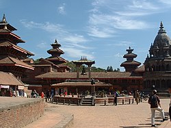
Hindu temples in Patan, the capital of one of the three medieval Newar kingdoms.
By the early thirteenth century, leaders were emerging whose names ended with the Sanskrit suffix malla ("wrestler"). Initially their reign was marked by upheaval, but the kings consolidated their power over the next two hundred years. By late fourteenth century, much of the country began to come under a unified rule. This unity was short-lived; in 1482 the kingdom was carved into three areas, Kathmandu, Patan, and Bhadgaon, which engaged in petty rivalry for centuries.
In 1765, the Gorkha ruler Prithvi Narayan Shah set out to unify the kingdoms, after first seeking arms and aid from Indian kings and buying the neutrality of bordering Indian kingdoms. After several bloody battles and sieges, he managed to unify Nepal three years later. However, the actual war never took place while conquering the Kathmandu Valley. Prithivi Narayan Shah was unable to defeat the powerful Newar kingdom of Kathmandu. In fact, it was during the Indra Jaatra, when all the valley citizens were celebrating the festival, Prithvi Narayan Shah with his troops captured the valley, virtually without any effort. This marked the birth of the modern nation of Nepal. A dispute and subsequent war with Tibet over control of mountain passes forced Nepal to retreat and pay heavy repatriations to China, who came to Tibet's rescue. Rivalry with the British East India Company over the annexation of minor states bordering Nepal eventually led to the brief but bloody Anglo-Nepalese War (1815–16), in which Nepal defended its present-day borders but lost its territories west of the Kali River, including present day Uttarakhand state and several Punjab Hill States of present day Himachal Pradesh. The Treaty of Sugauli also ceded parts of the Terai and Sikkim to the Company in exchange for Nepalese autonomy.
Factionalism among the royal family led to instability after the war. In 1846, a discovered plot to overthrow Jang Bahadur, a fast-rising military leader, by the reigning queen, led to the Kot Massacre. Armed clashes between military personnel and administrators loyal to the queen led to the execution of several hundred princes and chieftains around the country. Bahadur won and founded the Rana dynasty, leading to the Rana autocracy. The king was made a titular figure, and the post of Prime Minister was made powerful and hereditary. The Ranas were staunchly pro-British, and assisted the British during the Sepoy Rebellion in 1857, and later in both World Wars. In 1923 the United Kingdom and Nepal formally signed an agreement of friendship, truth, and law, in which Nepal's independence was recognised by the UK.
In the late 1940s, emerging pro-democracy movements and political parties in Nepal were critical of the Rana autocracy. Meanwhile, China regained control of Tibet in 1950, making India keen on stability in Nepal. King Tribhuvan offered then Indian Prime Minister accession of Nepal on the condition that he be made President of India. Nehru refused but sponsored KingTribhuvan as Nepal's new king in 1951, and a new government, comprising the Nepali Congress Party. After years of power wrangling between the king and the government, the democratic experiment was dissolved in 1960, and a "partyless" panchayat system was instituted to govern Nepal. In 1990, the "Jana Andolan" (People's) Movement forced the monarchy to accept constitutional reforms and establish a multiparty parliament in May 1991.[4] Krishna Prasad Bhattarai became the Prime Minister, drafted a new Constitution and carried out the democratic elections for the parliament. The Nepali Congress Party won the country's first democratic elections, with Girija Prasad Koirala becoming prime minister.
Recent developments
According to officials, on June 1, 2001, the Heir Apparent Dipendra is believed to have gone on a killing spree in the royal palace, in response to his parents' rejection of his choice of wife. His parents were killed and he died three days later. Some people, however say it was Gyanendra's son who was responsible for the killings. Following the carnage, the throne was inherited by Birendra's brother Gyanendra. In the face of unstable governments and a Maoist siege[4] on the Kathmandu Valley in August 2004, popular support for the monarchy waned.[5]
On February 1, 2005 Gyanendra dismissed the entire government and assumed full executive powers in the name of combating the Maoist movement.[4] In September 2005, the Maoists declared a three-month unilateral ceasefire which was not reciprocated by the royal government; the latter vowed to defeat the rebels by force. A few weeks later, the government stated that parliamentary elections would be held by 2007 even after the failed municipal elections.[6]
On January 14, 2006, the Maoists attacked five military and paramilitary installations throughout the Kathmandu Valley. Bombs were detonated in two of the locations. Twelve people died, eleven at the Thankot checkpost where multiple blasts shook homes as far away as Matatheirtha. The public was shocked as this was proof that the Maoists were able to organize and plan a simultaneous attack on multiple locations within the Valley, long considered to be relatively safe from Maoist violence. During the attack on the Thankot checkpost, a local toll station was robbed, which was located less than 100 metres away from an orphanage housing sixty-four children.
The Maoists, through support from the seven parliamentary parties (SPA),[7] arranged a mass uprising against the reign of King Gyanendra. The royal government used various means to quell the uprising. Frustrated by lack of security, jobs and good governance, thousands of people took to the streets to demand that the king renounce power outright, but the royal government turned even more ferocious and continued its suppression, including daytime curfews amid a Maoist blockade. Food shortages took effect. Soon there was a plan to hold a march with over one million people into the city center and encircle the royal palace. The security forces turned brutal. Thousands were injured and twenty-one people died in the uprising.
Foreign pressure continued to increase on King Gyanendra to surrender power. On April 21, 2006, Gyanendra announced that he was giving up absolute power and that "Power was being returned to the People". He called on the seven party coalitions to name a Prime Minister and that elections would be held as soon as possible. Both the U.S. and India immediately called on the SPA to accept this proposal. Many Nepalese protesters, however, still carried out rallies in numerous cities and vowed to continue the stir until they would achieve complete abolition of the monarchy. The SPA felt the pressure of these protests as some took place directly outside the deliberations of Gyanendra's offer. Finally, at midnight on April 24, after nineteen days' tumultuous protest, the king called for the country's parliament to reassemble on April 28.
Parliament has since reassembled and stripped the king of his power over the military, abolished his title as the descendent of a Hindu God, and required royalty to pay taxes. Furthermore, several royal officials have been indicted, and the Nepalese government is no longer referred to as "His Majesty's Government", but rather as the "Government of Nepal". Following Gyanendra's relinquishing of absolute power, the Nepalese government and Maoist rebels agreed on a ceasefire. In August 2006, both parties came to an agreement on the issue of arms accountability, agreeing to ask the United Nations to oversee and keep track of the weapons cache of both sides. The government and the Maoists are trying to come to an agreement on the future of the monarchy.
As of 15 January 2007, SPA and Maoists serve together in an Interim legislature under the new Interim Constitution of Nepal awaiting elections to take place in June 2007[8] to a Constituent Assembly, while all the powers of the Nepali King are in abeyance. On April 1, 2007 the SPA and the Maoist together formed an interim government.[9] The interim government was mandated to hold the Constituent Assembly elections in June 2007. But, constituent assembly election could not take place in June, 2007 because of the lack of security and delay in the verification of People's Liberation Army. Now, a new date, November 22, 2007, has been declared for Constituent Assembly Election.[5] The purpose of the constituent assembly election will be to rewrite the constitution and to decide the fate of monarchy in Nepal. with the possible abolition of the monarchy as part of constitutional change[6].
The Madhesay movement in the Terai area has recently demanded the end to discrimination against the Madhesay people. Thousands of Madhesay people came for the protests, in which more than 40 people have already died in the uprising. Recently, the government agreed to hold talks with the representatives of Madhesay group and few rounds of talk have also been carried out. However, there are still many conflicts between Madhesay people representatives and the government which need to be addressed in order to mitigate the problems of Terai people and bring in peace in the country.
But, it seems that Madhesay groups are now busy to settle the scores with maoists rather than to work to enhance the rights of communities. Being divided in many factions and groups, they have very diverse demands and government is unable to fulfill them[7]. Some Madhesay Party are demanding separate independent Madesh State[8] which seems to be completely unacceptable to other Madhesay leaders and Nepalese People. Some blame has been pointed towards India for encouraging such movements and demands in the Terai[9] as most of the madhesay are similar to Indian people residing in the Bihar and Uttar Pradesh States of India. India has been accused as creating instability in Nepal at a point when Nepal is slowly trying to revert to peace; though the allegation against India is not of a new kind.
Geography
Nepal is of roughly trapezoidal shape, 800 kilometres (500 mi) long and 200 kilometres (125 mi) wide, with an area of 147,181 square kilometres (56,827 sq mi). Nepal is commonly divided into three physiographic areas: the Mountain, Hill, and Terai Regions. These ecological belts run east-west and are bisected by Nepal's major river systems. Nepal is roughly the same size as the US state of Arkansas.
The Madhesi Plains bordering India are part of the northern rim of the Indo-Gangetic plains. They were formed and are fed by three major rivers: the Kosi, the Narayani (India's Gandak River), and the Karnali. This region has a hot, humid climate.
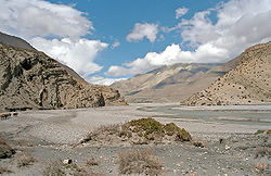
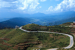
The Hill Region (Pahad) abuts the mountains and varies from 1,000 to 4,000 metres (3,300–13,125 ft) in altitude. Two low mountain ranges, the Mahabharat Lekh and Shiwalik Range (also called the Churia Range) dominate the region. The hilly belt includes the Kathmandu Valley, the country's most fertile and urbanised area. Unlike the valleysCalled Inner Tarai (Bhitri Tarai Uptyaka) elevations above 2,500 metres (8,200 ft) are sparsely populated.
The Mountain Region contains the highest region in the world. The world's highest mountain, Mount Everest (Sagarmatha in Nepali) at 8,850 metres (29,035 ft) is located on the border with China. Seven more of the world's fourteen highest mountains are located in Nepal: Lhotse, Makalu, Cho Oyu, Kanchenjunga, Dhaulagiri, Annapurna and Manaslu. Deforestation is a major problem in all regions, with resulting erosion and degradation of ecosystems.
Nepal has five climatic zones, broadly corresponding to altitude. The tropical and subtropical zones lie below 1,200 metres (3,940 ft), the temperate zone 1,200 to 2,400 metres (3,900–7,875 ft), the cold zone 2,400 to 3,600 metres (7,875–11,800 ft), the subarctic zone 3,600 to 4,400 metres (11,800–14,400 ft), and the Arctic zone above 4,400 metres (14,400 ft). Nepal experiences five seasons: summer, monsoon, autumn, winter and spring. The Himalaya blocks cold winds from Central Asia in winter, and forms the northern limit of the monsoon wind patterns.
Although Nepal shares no boundary with Bangladesh, the two countries are separated by a narrow strip of land about 21 kilometre (13 mi) wide, called the Chicken's Neck. Efforts are underway to make this area a free-trade zone.
Situated in the Great Himalayan Range in Northern part of Nepal, Mount Everest is the tallest mountain in the world. Technically, the south-east ridge on the Nepalese side of the mountain is easier to climb, so most climbers travel to Everest through Nepal. The Annapurna mountain range also lies in Nepal.m
Economy
Agriculture sustains 76% of the population and accounts for about 39% of the GDP; services comprise 41%, and industry 22%. Hilly and mountainous terrain in the northern two-thirds of the country has made the building of roads and other infrastructure difficult and expensive. There were just over 8,500 km of paved roads, and one 59 km railway line in the south in 2003. Aviation is in a better state, with 48 airports, ten of them with paved runways. There is less than one telephone per 19 people; landline services are not adequate nationwide but concentrated in cities and district headquarters; mobile telephony is in a reasonable state in most parts of the country with increased accessibility and affordability. There were around 175,000 Internet connections in 2005, but after the imposition of the "state of emergency", intermittent losses of service were reported. Uninterrupted Internet connections have resumed after the brief period of confusion as Nepal's second major people's revolution took place to overthrow the King's absolute power.[10]
Its landlocked location and[11] technological backwardness and the long-running civil war have also prevented Nepal from fully developing its economy. The country receives foreign aid from India, Japan, United Kingdom, United States, European Union, China, Switzerland, and Scandinavian Countries. The government's budget is about US$1.153 billion, with expenditures of $1.789bn (FY05/06). The inflation rate has dropped to 2.9% after a period of higher inflation during the 1990s. The Nepalese Rupee has been tied to the Indian Rupee at an exchange rate of 1.6 for many years. Since the loosening of exchange rate controls in the early 1990s, the black market for foreign exchange has all but disappeared. A long-standing economic agreement underpins a close relationship with India.
The distribution of wealth among the Nepalese is consistent with that in many developed and developing countries: the highest 10% of households control 39.1% of the national wealth and the lowest 10% control only 2.6%.
Nepal's workforce of about 10 million suffers from a severe shortage of skilled labour. Agriculture employs 81% of the workforce, services 16% and manufacturing/craft-based industry 3%. Agricultural produce——mostly grown in the Terrai region bordering India——includes rice, corn, wheat, sugarcane, root crops, milk, and water buffalo meat. Industry mainly involves the processing of agricultural produce, including jute, sugarcane, tobacco, and grain. The spectacular landscape and deep, exotic culture of Nepal represents considerable potential for tourism, but growth in this export industry has been stifled by recent political events. The rate of unemployment and underemployment approaches half of the working-age population. Thus many Nepalese move to India in search of work, the Gulf countries and Malaysia being new sources of work. Poverty is acute.[12] Nepal receives US$50 million a year through the Gurkha soldiers who serve in the Indian and British armies and are highly esteemed for their skill and bravery. The total remittance value is worth around 1 billion USD, including money sent from Persian Gulf and Malaysia, who combined employ around 700,000 Nepalese.
Nepal's GDP for the year 2005 is estimated at just over US$39 billion (adjusted to Purchasing Power Parity), making it the 83rd-largest economy in the world. Per-capita income is less than US$ 300. Nepal's exports of mainly carpets, clothing, leather goods, jute goods and grain total $822 million. Import commodities of mainly gold, machinery and equipment, petroleum products and fertilizer total US$2 bn. India (53.7%), the US (17.4%), and Germany (7.1%) are its main export partners. Nepal's import partners include India (47.5%), the United Arab Emirates (11.2%), China (10.7%), Saudi Arabia (4.9%), and Singapore (4%).
